West Fork Madison
A Trout Unlimited-led restoration project supported by the Madison River Foundation
The West Fork Madison is one of the Madison watershed's best nurseries for wild trout. Acting now allows us to address a growing floodplain problem before it permanently alters the river, protecting the cool, shaded habitat that makes the West Fork such and important nursery for wild trout.
We Need Your Help Raising ONLY $40K
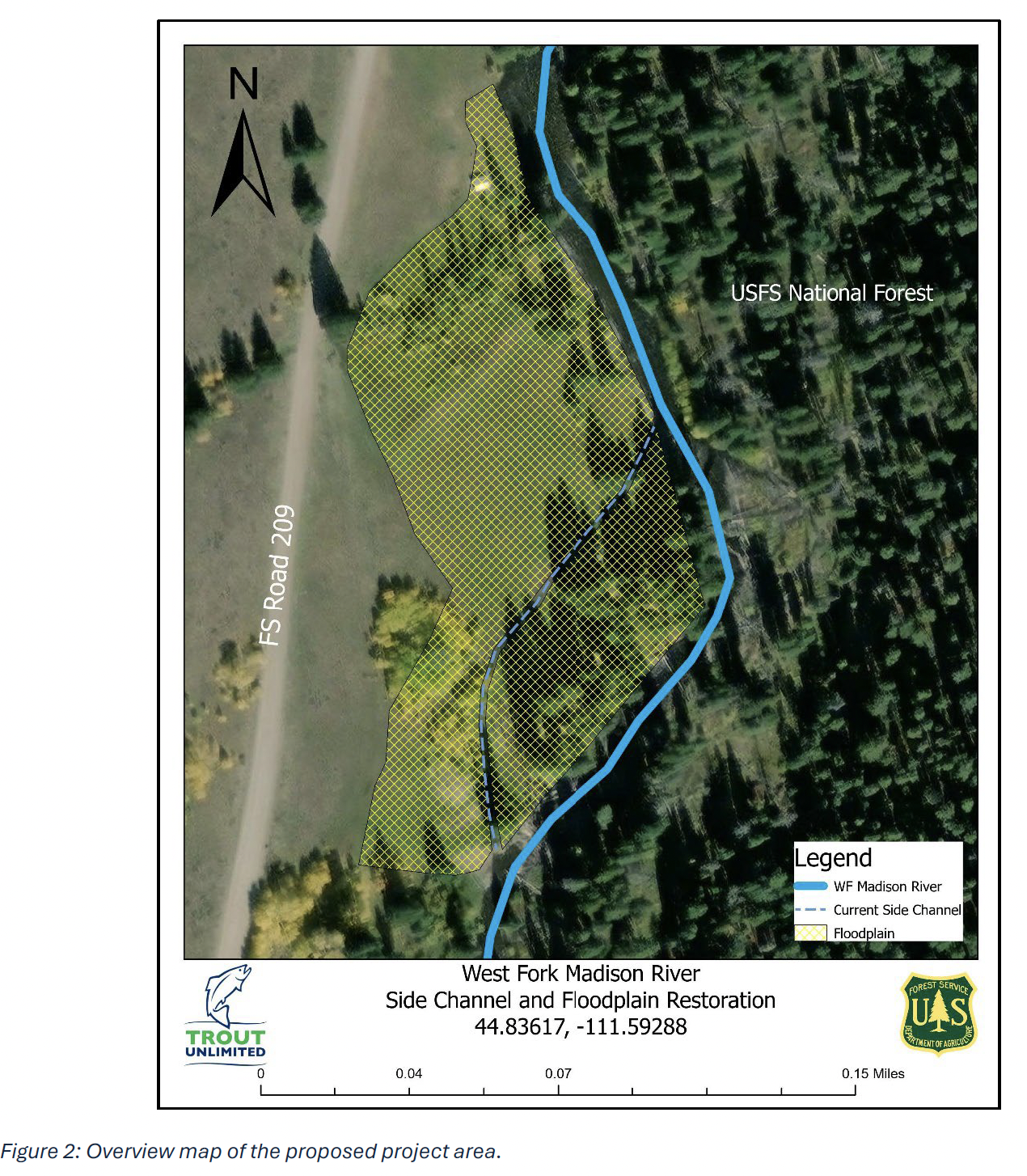
West Fork Madison Side Channel and Floodplain Restoration
The West Fork Madison joins the mainstem Madison River about 10 miles downstream of Quake Lake, draining 157 square miles of the Gravelly Mountain Range. Recognizing its importance to the Madison River fishery, Trout Unlimited is leading restoration efforts in this critical watershed. Unlike most major tributaries in this stretch of the watershed, the West Fork sits almost entirely within National Forest land and avoids the seasonal dewatering that affects many agricultural tributaries, making it an important nursery for juvenile trout before they migrate down to the mainstem.
Despite this advantage, the West Fork is listed as impaired by the Montana Department of Environmental Quality for elevated water temperatures, driven largely by degraded streamside vegetation from historic land use and ongoing recreational and grazing pressure. As a popular destination for camping, off-roading, hiking, and fishing throughout the year, the floodplain along the West Fork bears the brunt of that recreational impact.
The Problem
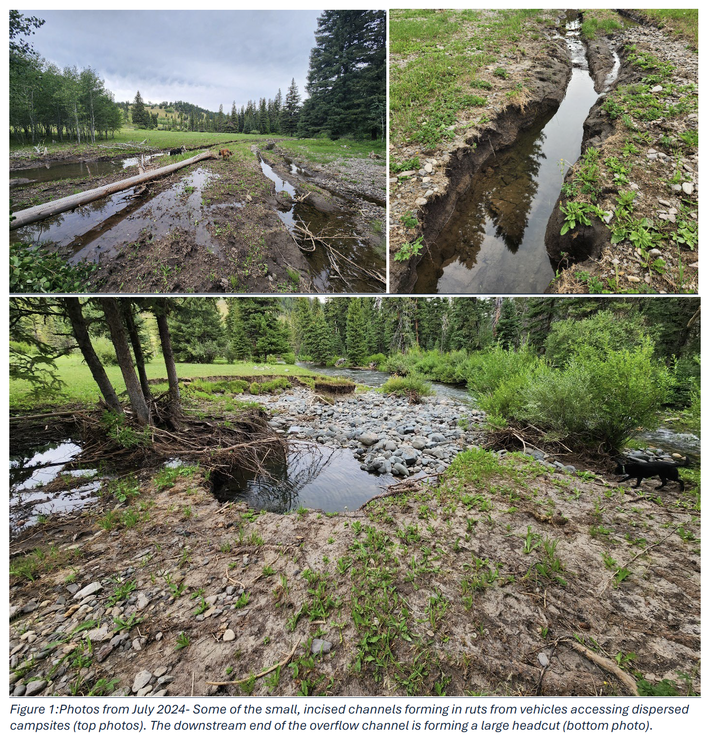
In 2023, Trout Unlimited and project partners identified more than 20 dispersed campsites along the West Fork causing soil compaction, streambank trampling, and a loss of the riparian vegetation and floodplain roughness that normally slow and absorb high water.
One site, at river mile 4.7, has become an urgent concern. Vehicle ruts from years of dispersed camping gave high spring flows a path off the main channel and onto a 5-acre floodplain. Without roughness to slow it down, that overflow water has carved a headcut that continues to migrate upstream, currently forming a side channel roughly 620 feet long. Left alone, the headcut threatens to pull the entire West Fork out of its well-shaded, structurally complex channel and into a wide open field with no shade, little instream structure, and a falling water table, worsening the very temperature impairment the river is already fighting. The U.S. Forest Service has closed the dispersed campsite to prevent further damage while a long-term fix is developed.
The (Proposed) Plan - Final Direction and Action is still being considered
Side Channel Construction – GEUM Environmental Consulting firm will reshape the current overflow channel into a stable, meandering channel reinforced with woody debris, and step down the headcut to stop its upstream march. Done right, the new channel could become year-round habitat for fish and wildlife rather than a hazard.
Revegetation – Native riparian species, including chokecherry, willow, dogwood, aspen, and cottonwood, will be planted along the streambanks and floodplain, with willow cuttings sourced from healthy stands nearby. Disturbed soil will be seeded with native grasses and sedges, and weed control will keep invasives from taking hold while plantings establish.
Floodplain Roughness – Partially buried wood and willow trenches will be added across the floodplain to slow overbank flows, discourage foot and vehicle traffic, and give new vegetation room to establish.
Fencing or Rock Barriers – Jack leg fencing and rock barriers will define camping areas and keep vehicles off the floodplain while still leaving access points down to the water, so recreationists can enjoy the West Fork without degrading it further.
Partners
This project is led by Trout Unlimited in partnership with the USFS Beaverhead-Deerlodge National Forest, Madison River Foundation, Northwestern Energy, Montana Fish, Wildlife & Parks, GEUM Environmental Consulting